| |
|
Cyclones and hurricanes
Now and then the news shows us the devastating effects of these tropical depressions which, quite understandably, worry everyone who visits the Antilles.
‘Cyclone’ is the usual term in the French islands and comes from the circular movement of the phenomenon (from the Greek kuklos: circle). The technical English term for the phenomenon is Tropical Revolving Storm, more commonly ‘hurricane’, although strictly the latter technically applies only to cyclones above a certain strength.
This meteorological phenomenon is not restricted to the Caribbean, it affects all the world’s tropical zones. In SE Asia they are called typhoons.
What is a cyclone?
Classification
Wind strength determines the three-stage classification of cyclones:
•Tropical depression: less than 34kn (63kmh)
•Tropical storm: 34–63kn (117kmh)
• Hurricane: over 63kn
Tropical storms and hurricanes have names which begin each year with the letter A and alternate male and female names.
Hurricanes proper are classified by the five level Saffir and Simpson Scale:
Category 1 64–82kn (153km/h)
Category 2 83–96kn (177km/h)
Category 3 97–113kn (209km/h)
Category 4 114–134kn (248km/h)
Category 5 over 134kn
It is important to remember that whilst all hurricanes have their origins in tropical depressions, not all tropical depressions become hurricanes.
Note Of the 70 areas of tropical circulation that occur annually, less than 10% become hurricanes.
Season
Sea temperatures reach their maximum at the end of summer (28°–30°) and lead to the greatest occurrence of cyclones in August and September. That said, the danger period starts at the beginning of the summer and lasts until October and, more exceptionally, November (for example Hurricane Lenny from 13–21 November 1999).
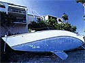
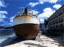
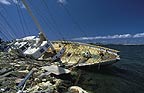
Destructive effects
Principal effects: Floods, destructive winds, phenomenal sea state and swell, storm tides.
|
|
|
|
Examples and characteristics of selected hurricanes
David
One of the most powerful and long lasting (Category 5)
25.08.1979 depression forms near the Cape Verde Is
27.08.1979 becomes a hurricane
29.08.1979 centre passes N of Martinique and hits the S of Dominica
Characteristics (at the storm’s strongest):
The cloud mass extended over an area more than 800 nautical miles in diameter.
Central pressure: 932Hpa
Maximum sustained wind (excluding gusts): 140kn
Hugo
Extremely violent and devastating (Category 5)
11.09.1989 depression forms off Africa
13.09.1989 becomes a hurricane when over the Atlantic
16–17.09.1989 hits the Leeward Is and then the Virgin Is
Characteristics:
Central pressure: 942Hpa Speed of advance: 11kn Maximum sustained wind (excluding gusts): 120–140kn
Warning signs for approaching hurricanes
These are generally: (for a normal E–W track a large, long E’ly swell unless the speed of advance of the hurricane is faster than the wave train)
•a rise in water level
•a drop in the barometer
•cirrus clouds
For more details about this chapter, please refer to the Guide 'Grenada to the Virgin Islands

|
|
|